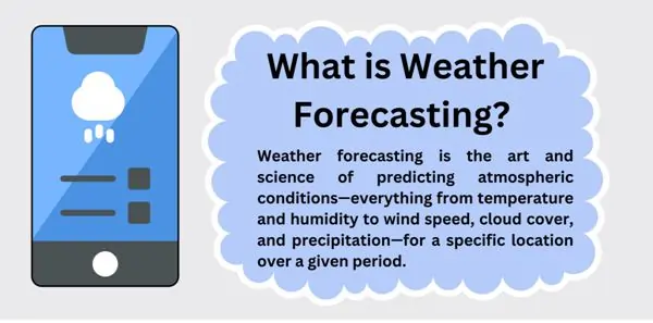
What is Weather Forecasting?
Weather forecasting is the foresight of the weather, thus temperature, humidity, wind speed, cloud cover and even precipitation within a given period of time in a particular region can be predicted. It is like getting a sneak preview of Mother Nature’s calendar to tell you what she has lined up for us.
How Is It Done?
Observations and Data Collection
Meteorologists gather data from various sources: Weather stations, satellites, radar, buoys and even balloons used in the determination of the state of the weather at any given point in time.In this case, these observations give important data on temperature, pressure systems and trends, wind and humidity.
Numerical Weather Prediction (NWP)
Today most predications are done mathematically. NWP models predict the behaviour of the atmosphere based on data that is subdivided into a set of cells and calculated with help of fundamental equations like Navier-Stokes. Supercomputers count these up in order to know how the atmosphere will develop in the future.
Model Integration
The NWP models represent the evolution of the atmosphere in time. They include solar radiation, air pressure gradient and Coriolis force into consideration.It divides the separate regions accordingly.
Ensemble Forecasting
Meteorologists perform a single model simulation with different input data and boundary conditions (ensembles).Forecasts are given by ensembles together with allowance for the variance.
Post-Processing
Raw or independent model outputs are therefore often not in a format that can be directly or at least easily used in a decision-making process or presented to a decision-maker. Meteorologists also put it in relation to local influences such as mountains or coasts and trends into consideration. They also employ other statistical tools to enhance on the forecast made.
Visualizing the Forecast
Graphics increase the usability of data into forecasts embodied in maps, charts and other illustrations. The example of logos is weather icons people are familiar with; sun, clouds, and raindrops.
Human Expertise
To the data analysed by computers meteorologists apply their human touch and experience. They think about patterns, climatology, and knowledge on the population area.
Short-Term vs. Long-Term
The data availability is higher for short range forecasts with the time span ranging from hours to a few days. Short term predictions (weeks in advance) are slightly more difficult and include such climate phenomena as El Niño.
Role played by Satellites in weather prediction
Polar-Orbiting Satellites (LEO Satellites):
They move around the planet from the North Pole to the South Pole position thus getting round view of the Earth twice in a day. From their perspective which is around 540 miles above the surface of the earth, they study the atmosphere, seas and the territories. Their constant presence over the globe contributes to the crucial information to be used by weather forecasts.
Data Collection
As we have already mentioned satellites are like our eyes in outer space observing the surface and atmosphere of Earth.Cloud cover, wind pattern, humidity, Wind speed and temperature, all these can be predicted.As one can imagine, some of these measurements are transmitted back to the Earth and meteorologists convert such into useful pictures and information.
Numerical Weather Prediction
A key component of today’s forecasts is NWP models.These are based on model equations. In this more then 3/4 of data is collected by LEO Satellites. Their observation assists in constructing the right base or initial condition – the deterministic starting point for forecasts.
Rapid Refresh Forecast System
It a state-of-art system that has been in use recently in 2024, that transform short-term forecasts, that is important for conditions such as aviation and stormy weather conditions. How does it work? From the instruments carried on LEO satellites, satellite radiance data can be utilised.
Global View and Complementing Ground-Based Systems
Satellites provide views from above and across the globe that are helpful in addition and expansion of the ground-based networks such as Weather radar and Surface observations. They assist in the monitoring of constantly evolving weather patterns, detection of storms and subsequent movements of these storms. If it were a hurricane in the Atlantic or monsoon clouds over the Indian sub-continent, satellites provides early alert.
Continuous Monitoring
As it has been established, satellites do not have the luxury of time to ‘sleep’ the way ground-based stations do. They are constantly watching the whole world non-stop and delivering updates about it. The inclusion of the forecaster in the active generation of information means that this continuous stream of information can help to refine the forecasts.
Weather forecasting in India
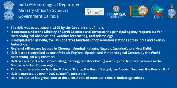
India Meteorological Department (IMD)
Indian Meteorological Department is the premier organization for the purpose of providing weather forecast in India.It was set up in 1875 and comes under the Ministry of Earth Sciences.IMD disseminates climate information including forecasts, warning or advisories for different time horizons including daily, and seasonal. To get the current and forecasted weather conditions you can log on to the IMD website:
https://mausam.imd.gov.in
Satellites
India continues to make use of both home grown and foreign satellites for weather forecasting. ISRO, the Indian Space Research Organisation is responsible for the launching and operation of these satellites. These satellites give important information on cloud amount and type, precipitation, temperature, and other states of the atmosphere. It is very important to them to enhance the reliability of forecasted meteorological conditions.
Private Weather Services
Besides government departments, there is private weather producing organizations and companies that play part in providing weather whereby. Players such as Skymet Weather Services offer localized, special forecasts to enterprise for agriculture and other industries as well.
Collaboration with Global Agencies
Geography does not differentiate between the countries and hence international cooperation with agencies is crucial. India has data sharing with these global bodies such as the World Meteorological Organisation (WMO) as well as the European Centre for Medium-Range Weather Forecasts (ECMWF).
Challenges associated with the weather Forecasting in India?
Data Scarcity
- AI and Data Dependence: As the world passes towards the AI based weather predictions, India itself struggles with the absence of accurate detailing. AI and most of the machine learning algorithms depend on the wealth of raw, unstructured, formatted data. However, in a country like India compiling such data is difficult mostly for the regions like Himalayas.
- Himalayan Data Gap: In major Himalayan states, glaciological information is underway and plays important roles in weather conditions, however, maps of glacial lakes are very scarce and actual research on glacial lakes is not more than 30% of the recorded glaciers. Such scarcity hampers the establishment of AI derived early warning systems of events such as glacial lake outburst floods.
Localized Predictions:
- Mission Mausam: Due to unpredictable weather, India is hit with the problem of both floods and Drought at the same period. Thus, to avoid these risks, development of the better forecasts on more small scale, including Panchayat level, will be helpful.
- High-Resolution Data: High definition data is essential in making accurate forecast and this may be difficult to achieve consistently across the various regions.
Monsoons and Cyclones
- Monsoon Variability: Monsoon period plays a very important role in agriculture and water harnessing in the Indian sub-continent. Forecasting of monsoon or the onset, intensity and extent of the monsoon also remains a challenging task due to the variability in the monsoon system.
- Cyclone Tracks: Cyclonic areas are affected by cyclones mostly the coastal areas. It is therefore very crucial to track storms and predict their landfall so as to plan in advance for the disaster.
Urban Microclimates
- Urban Heat Islands: Since they were created, cities have their climate influenced by concrete, by asphalt, and population density. Urban weather forecasting is very important for overall health and structures especially during the process of planning.
Extreme Events
- Heat waves and Cold Spells: In India there is a lot of variations in terms of temperature. Heat and cold alerts are urgent so as to avoid the conditions leading to the sicknesses and cold deaths respectively.
- Flash Floods: Heavy showers can causes flash floods because most cities have a poor system of dealing with water.
Climate Change Impact
- Changing Patterns: Extreme climate shifts occur regularly making it difficult to rely on past climate as a mode of predicting future climate change.
- Sea Level Rise: They feel the brunt of increasing sea-level that affects storms and floods in the region.
How does the weather forecasting assist in the conditions of Disasters?
Weather and other calamities is a complex issue which is not easily solved by one country alone.Weather forecasting is much more than deciding to take an umbrella or a hat or wear a pair of shades or not. It is a source of hope in special incidents such as natural disasters. Here’s how it helps:
Early Warnings
- Hurricanes, Cyclones, and Typhoons: Especially when these tempests occur over the warm ocean waters accurate and timely predictions are important. The characteristics, the progression, and areas of contact with earth are recorded by forecast models. These warnings enable the people in various communities to leave with their properties, prepare for disruptions.
- Tornadoes: These fierce funnels of destruction can be developed very fast. Early warning fosters people’s extra minutes to run for cover.
- Floods: Rainwater that falls heavily, the rivers are over flooded and storm surges – it is possible to predict areas that are prone to floods. People are warned by different authorities, and the population evacuates the areas at risk.
- Droughts: Some of the impacts of drought include impact on crop and food production, water resources and other impacts on ecosystems. These predictions assist farmers to predict on irrigation and even manage other resources.
Precision Matters
- Localized Forecasts: Weather models come up with many micro predictions of the weather. For instance, how much would one wish to know that such streets can flood during the next down pour? That’s precision!
- Urban Heat Islands: They retain heat thus causing heat island effects, Forecasting assists in lessening health complications due to heat.
Emergency Response
- Resource Allocation: This is the case because emergency services plan and then act based on respective forecasts. Fire, rescue, emergency, and the relief team and put their outfit on.
- Evacuation Routes: Possible storm tracks define where people must go in order to evacuate. Just think of the state of the world if such information is absent!
Agriculture and Economy
- Crop Planning: Forecasts are used by farmers in the areas of planting, harvesting and in controlling pests.
- Business Decisions: Such industries as airline, shipping and construction have to make changes to their plans based on the weather forecast.
Climate Change Adaptation
- Rising Sea Levels: Coastal cities are on the vulnerable list. These forecasts assist in planning for defence and relocation.
- Extreme Events: High events are characteristics of climate change, thus meaning that events will be more frequent as climate changes. Forecasts aid adaptation.
Community Awareness: Education and Preparedness: Weather updates as a routine make people be aware. Communities which are prepared are also those that receive minimal damage during a disaster.