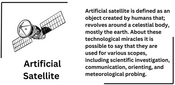
Artificial satellite is defined as an object created by humans that; revolves around a celestial body, mostly the earth. About these technological miracles it is possible to say that they are used for various scopes, including scientific investigation, communication, orienting, and meteorological probing. Now is the time to provide some information on what artificial satellites are what types exist and why are they important.
Artificial Satellite?
Artificial satellite could be defined literally as any object that has been purposefully placed in orbit by human beings. Artificial satellites are not meteorites or moons, which are satellites of other planets, but create, designed, and activated by governments, privately held corporations, or university researchers. Satellites are very important in today’s world and are used for communication, monitoring the earth’s surface and space research.
Types of Artificial Satellites
Communication Satellites
This kind of satellite assists in telecommunication by acting as a medium that transmits signal from ground station to another ground station. They operate on geostationary or geosynchronous orbits, and, thus, they do not change their position relative to a certain point of the globe. Examples: Intelsat, Inmarsat and Astra satellites.
Earth Observation Satellites
These satellites take pictures or record information regarding surface features; the atmosphere, seas and the global climate. They assist in development of environment, management of disaster and in planning and designing of cities. Examples: Landsat, Sentinel, and MODIS satellites are some of the famous Satellites.
Navigation Satellites
These are the satellites used for the navigation and GPS is its most common example. It is an indispensable accessory to give correct location data for guidance, location, or timing. Examples: GNSS systems that include the GPS of U.S., GLONASS of Russia, and Galileo that is from the European Union, and the BeiDou from China.
Weather Satellites
Meteorological satellites observe weather and climatic conditions, clouds, and temperature of the atmosphere. They assist weather forecasters to forecast weather occurrences, and monitor cyclones. Examples: NOAA Satellites of United States and Meteosat satellites of the European Space Agency.
Scientific Satellites
There is still Scientific satellites and explorations. They examine things like cosmic rays, magnetic fields and Space Weather. Examples: The facilities include Hubble Space Telescope, Chandra X-ray Observatory and rovers for the Mars surface.
Spy Satellites (Reconnaissance Satellites)
They are essential tools in military and intelligence wherein it photographs distant objects clearly and investigate on-going actions on earth.
Artificial satellites have significantly brought changes in our understanding about the nucleus of the universe and in our daily existence. They moved from making communication very easy to facilitating the tracking of climate change, among other fields that define our technological developments. Thus, in the future a variety of scientific discoveries and practical application of satellite technology will only increase.
What is a geostationary orbit
A geostationary orbit also referred to geosynchronous equatorial orbit (GEO) is a quite unique path that satellites take in orbit our planet.
- Position and Altitude: Basically, a geostationary orbit can be placed about 35786 kilometres (22,236 miles) directly above the Equator.Most importantly the satellite that inhabits this orbit rotates in the same direction with the Earth.
- Orbital Period: A satellite that is positioned at GEO takes exactly 24 hours to make a round of the Earth while the Earth itself also takes a similar time to complete a rotation on its axis – what is known as a sidereal day.
- Apparent Stationary Position: This type of orbit locates satellites over the earth’s surface and shows the satellite in the same position all the time when viewed from the earth.Think about the possibility of at some point having a satellite hovering above the same space which could be any satellite: a communication satellite, a weather satellite or whichever.
- Applications:
- Communication Satellites: A significant number of communication satellites are positioned in the geo stationary orbit.
They orbit the Earth at a fixed position and therefore it does not require manoeuvring to constantly position the ground based satellite antennas at it.
- Weather Satellites: These satellites help monitor weather conditions, cloudy sky and or climate of the areas being covered within short span of time.
- Navigation Satellites: While most navigation satellites such as the GPS is not in Geostationary orbits, these satellites are very important in positioning systems around the world.
How Navigation Satellites Work
GPS satellites and other navigation tradition incorporate technology that has been placed into orbit with the help of a mix of space technology, accurate time, and a great deal of mathematics. Here’s a simplified overview:
Satellite Constellations
There are a group of satellites which are placed in different orbits around the earth. For GPS there are more than thirty satellites available on a constellation.Such satellites are located in several orbital planes which provide adequate worldwide coverage.
Atomic Clocks on Board
Every satellite has on board highly accurate atomic clocks. These clocks therefore are always ever ticking, and with due accuracy in terms of time.
Signal Transmission
Satellites always broadcast in manner whereby radio waves are employed as the means of conveying information. These signals consist of position of the satellite and the actual time that signal was sent out to the GNSS receiver.Satellites always broadcast in manner whereby radio waves are employed as the means of conveying information. These signals consist of position of the satellite and the actual time that signal was sent out to the GNSS receiver.
Receiver on Earth
Your GPS receiver (whether it’s in your phone, car or handheld device) listens for these signals. This is when your receiver is actually receiving signals for at least not less than four satellites which engage in mathematical calculation.
Trilateration
The main idea of the form can be identified as trilateration. Here’s how it works, your receiver determines the distance to each satellite considering the amount of time that the signals have taken in traveling from the satellite to your receiver. The time delay tells you the distance. Let me paint a picture for you, try sketching circles around each satellite with a radius of the distance determined above. The place where all these aforementioned spheres coincide is the exact spot in the world where you are!
Determining Your Position
By examining the distances to a number of satellites your receiver calculates your location. It determines the geographic latitude and longitude, and geographic altitude or altitude above-mean sea level.
Enhancements and Accuracy
Satellite navigation systems also incorporate not only the geometric distances but also such parameters as the ionosphere, which influences the signals and relativistic effects because the satellites are moving rather fast.Additional systems are augmentation systems such as WAAS of the USA or EGNOS of Europe which helps in further increase in accuracy.
Independence from Telephony or Internet
GPS operates without touching cell towers or internet connection.Hence even if you are in the rural areas where buildings or trees may obstruct your view of the sky, the GPS can determine your location.
Some of India’s Most Prominent Artificial satellites
The Indian Space Research Organisation ISRO has been very active in space exploration and has been delivering its best by achieving astounding feats. In communication satellite launch as well as interplanetary missions, ISRO’s involvement is etched indelibly into the global space history.
Chandrayaan Missions
Chandrayaan-1 (2008)
- Objective: The first Indian conceived lunar mission was Chandrayaan-1 whose goal was to launch an orbiter to explore the Moon.
- Achievements: Successfully insertedin lunar orbit. Detection of water molecules. Also contributed to the enhancement of India’s space program through presentation of home grown technology.
- Impact: Chandrayaan-1 provides the basis for more LM missions.
Chandrayaan-2 (2019)
- Objective: Noble gas hydrates to locate water on the moon and for research on the moon’s surface.
- Achievements: Orbiter functional; lander carried out a soft landing exercise (however it crashed because of a software malfunction). It Showed India’s ability of having a lunar exploration mission.
- Significance: Chandrayaan-2 gave deeper insights about the composition of Moon.
Chandrayaan-3 (2023)
- Objective: Exploring the soil of the lunar surface safely and mobilizing on it safely.
- Achievements: successful lunar landing in August 2023. Conducted technology demonstration experiments.
- Impact: Chandrayaan-3 is a living testimony to India’s capability of exploring moon.
Aditya-L1: India’s Solar Mission
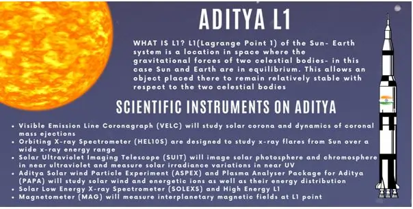
- Objective: Learn about the solar corona as well as chromosphere.
- Recent Achievement: Aditya-L1 spacecraft successfully launched and inserted at the final operational orbit at the Sun-Earth Lagrangian point (L1) in the month of January, 2024. It is working for A meaningful discovery towards the explaining the phenomena of the sun and the space weather.
The Indian National Satellite (INSAT) and Indian Remote Sensing (IRS) System
INSAT System: It is mostly used for broadcasting, communication and Disaster warnings. Fosters better communication as well as weather reception in India.
IRS Satellites: Supervise natural resources, farming, tree plantations and growth of cities.India has launched high resolution Cartosat and radar imaging RISAT satellites have been successfully launched.
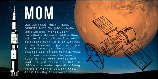
Mars Orbiter Mission (Mangalyaan)
- Objective: Placement in orbit of Mars and observing the surface and the atmospheric conditions of Mars.
- Achievements: It was launched in 2013 and reached Mars’ orbit in year 2014. India successfully targeted the Mars orbit making it the first Asian nation to do that. It was the most Cost-effective and efficient mission.
- Legacy: Through Mangalyaan, the world got to witness the complexities of ISRO and moreover its low-cost approach and capability to reach other planets.
Conclusion
This is the inspiring journey of ISRO from a initial level science organization to cross planetary boundary to accomplish a historic success. These principles ensure a policy of innovation, economic operation and indigenous technology they have endeared themselves to the years and beyond space exploration epoch.