Authorities widened the danger zone surrounding Mount Lewotobi Laki Laki volcano because the volcano erupted multiple times on March 21st, 2025 with volcanic columns rising 8,000 meters (26,200 feet).
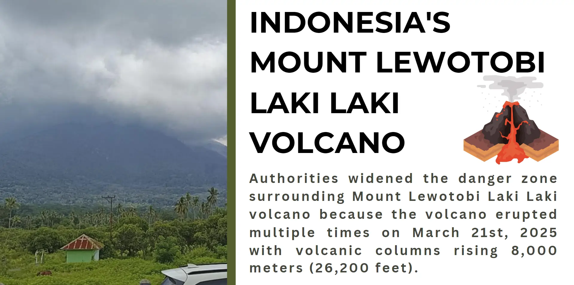
Thousands of people living near Mount Lewotobi Laki Laki exhibited risk due to an eruption because authorities pulled their warning status for human life safety and sustainable development protection. The eastern Indonesian island of Flores hosts two volcanic peaks which include Mount Lewotobi Perempuan together with Mount Lewotobi Laki Laki. Volcanic eruptions frequently happen in Indonesia since it resides inside the Pacific "Ring of Fire" area yet each outbreak brings its own specific combination of problems and effects. Authority forces began expanding areas under danger while implementing protective measures due to instant threats from volcanic plumes and seismic movements and possible lava flows. This article delves into the impact of the eruption on communities, infrastructure, and the environmental and historical context of Mount Lewotobi Laki Laki.
The Eruption Event
Another volcanic eruption at Mount Lewotobi Laki Laki brought Indonesian volcanic events to worldwide attention for the second time. Volcanic materials together with ash rose from the active volcano situated in Flores Island and the East Nusa Tenggara province during its current volcanic event.
During the event Mount Lewotobi Laki Laki produced high-reaching ash plumes along with a visible volcanic outbreak. Sounds and seismic shaking occurred simultaneously during the eruption because the underground activity reached high levels. The local authorities distilled alert messages while simultaneously expanding the protective perimeter of the volcano to protect inhabitants. Local authorities in this area now work with heightened caution because lava flows and ash cloud movements and potential landslides and mudflows exist as active threats to the region. Emergency evacuations were performed by the authorities to safeguard residents living near the active volcano region.
Mount Lewotobi Laki Laki belongs to an exclusive pair of twin volcanoes as it stands alongside Mount Lewotobi Perempuan. These two volcanoes show different geological variations while being important elements that form Indonesia's volcanic features. As the Pacific “Ring of Fire” touches Indonesia this nation maintains the highest concentration of active volcanoes known to the planet. Earth’s crust and tectonic plate subduction during their contact has created this volcanic arc that shows on-going seismic and volcanic activity.
A tropical landscape combined with agricultural settlements and villages describes the geographic region containing Mount Lewotobi Laki Laki. When Mount Lewotobi Laki Laki erupts it creates difficulties for people who live there while transforming the natural environment at both human residential and ecological levels. Mount Lewotobi's geological behaviour is carefully scrutinized through volcanic science because researchers study its activity shaped by multiple underground magma chambers alongside tectonic fault systems.
A recent eruption demonstrates the heightened environmental risk within Indonesia's territory. Living among the natural surrounding where people confront the inevitable dangers in a rapidly changing geological environment is difficult. Public authorities and experts together with local populations conduct on-going monitoring of the eruption aftermath to mitigate its effects while demonstrating that area remains strong despite its problems.
Effects Volcanic eruptions can cause:
Multiple effects generated by volcanic eruptions such as Mount Lewotobi Laki Laki make their way through social groupings as well as physical infrastructure and environment and ecological networks. The effects of these events lead to urgent situations which also produce lasting environmental effects.
Impact on Communities
Mount Lewotobi Laki Laki eruption caused major disruptions to the populations residing near its active zone. The expanded danger area puts towns at critical evacuation requirements that lead to community displacement together with emotional hardship affecting local residents. Resident families touching the volcano must leave both their properties and living quarters in order to defend their safety. The ash particles released into the air result in poor air quality that creates respiratory health risks to children and elderly people. The implementations of school and market closures disrupt educational operations and commercial activities. Agricultural Farmers encounter economic burdens from the volcanic eruption because the ash blanket contaminates land and destroys crops while diminishing soil fertility.
Impact on Infrastructure
Volcanic eruptions create the greatest risk to infrastructure elements that dwell close to the volcanic mountaintop. Small volcanic ash particles floating in the air present a major aviation hazard because they obstruct engine operations of aircraft causing flight delays. The disruption of airline transportation between Bali and close airport terminals leads to temporary flight cancellations that harm tourist visits and trading operations. The evacuation process along with supplies delivery through roads and communication systems becomes slower because volcanic ash blocks and damages transportation structures. Ash contamination of water supply systems causes drinking water shortages because water becomes dangerously contaminated.
Environmental Impact
The environment absorbs severe negative consequences during volcanic eruptions. Sulphur-dioxide gas emissions into the air lead to environmental pollution and they have a direct impact on global climate patterns. The massive volcanic eruptions cause temporary global temperature decreases through the reflective capabilities of volcanic aerosols. Heavy ash-fall in the local region transforms land features while affecting water pathways which might result in floods that modify river directions. A rapid transformation of land elevation creates new research prospects in geology at the cost of endangering environmental habitats.
Ecological Impact
The environmental results of volcanic eruptions affect both Flora and fauna in the region. When volcanic materials and lava flows strike vegetation they destroy it entirely and ash deposits render the soil so acidic that plants struggle to grow. The elimination of forests together with agricultural lands and ecosystems results in animal migrations and compels them to adjust according to modified environmental conditions. The altered landscape becomes a challenge for wildlife species because it restricts their access to food along with proper shelter. Mosses and lichens demonstrate adaptation to volcanic soil during its development as such areas eventually help in restoring the ecosystem.
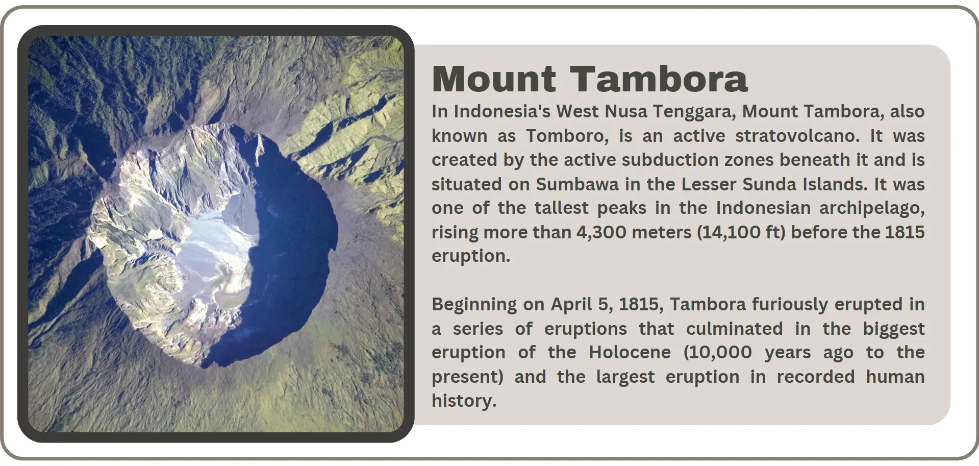
Examples: The Indonesian Mount Tambora's 1815 eruption resulted in crop-destroying volcanic activity that produced global lack of summer weather patterns with widespread famine. The surrounding communities along with ecosystems near Mount Lewotobi Laki Laki will experience enduring effects resulting from its recent eruption. The affected areas urgently need increased monitoring and response systems to cut down on dangers and strengthen their resilience.
What is a Volcano?
“Geological formations named volcanoes serve as openings that allow molten rock together with gases and other Earth crust materials to travel from depth to the surface.” Sudden released underground heat and pressure push magma up through Earth's crustal openings to create these volcanic outflows. The term lava applies to magma the moment it breaches the surface. The destructive power of volcanoes serves two functions since volcanic activity contributes to geological landscape formation and supports soil quality elevation and controls climate conditions.
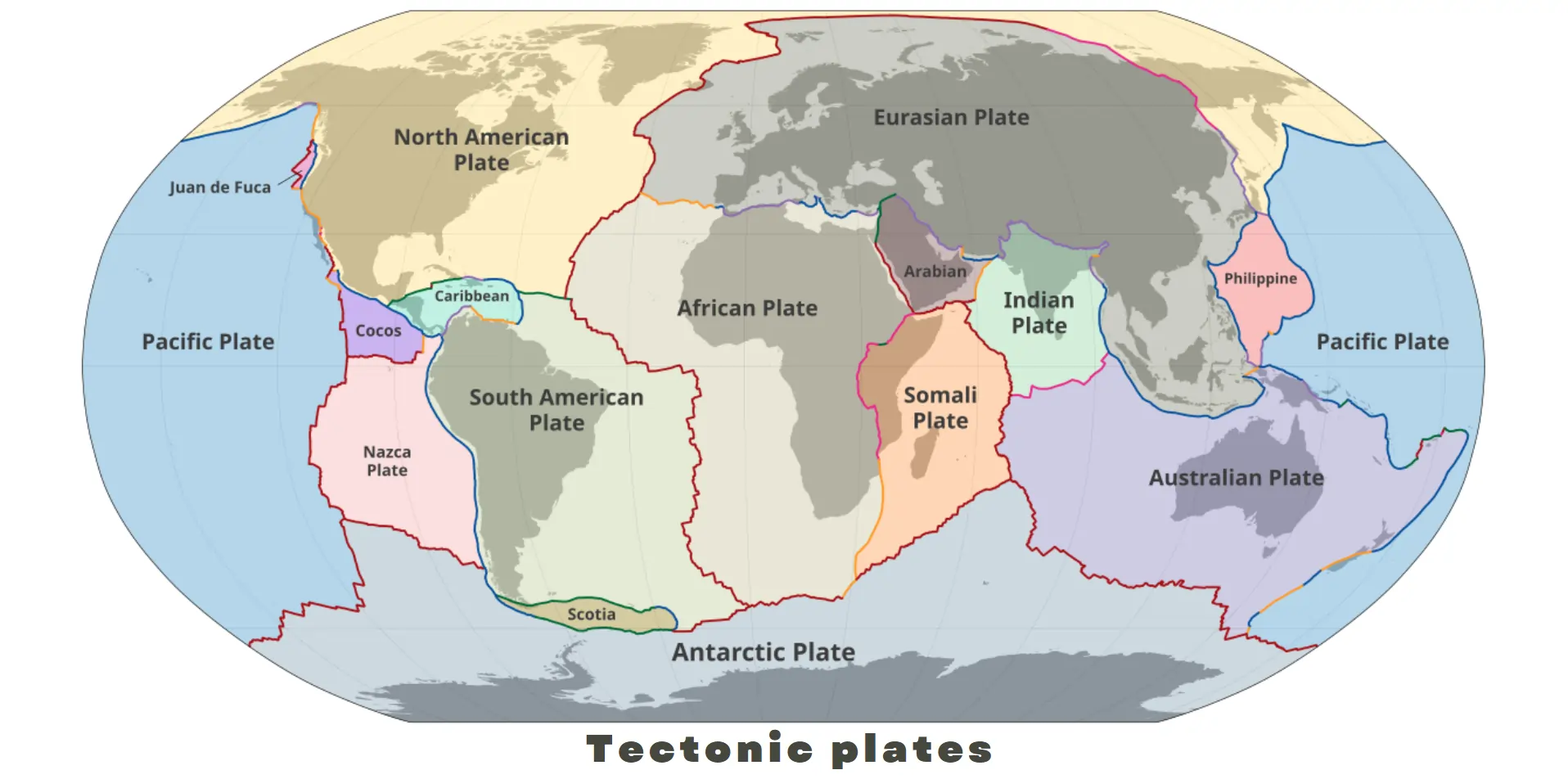
Most volcanic structures develop close to the locations where different tectonic plates interact either by approaching one another or separating from each other. Volcanoes located above hotspots are regions in which deep mantle plumes carry magma to the surface like the Hawaiian Islands demonstrate. People have been captivated by volcanoes throughout the past few centuries because of their enormous destructive power as well as their unpredictable nature.
Types of Volcanoes
Volcanoes receive their categorizations through evaluations of their structural characteristics alongside their dimensions as well as eruption characteristics. Here are the main categories:
- Shield volcanoes: these are wide and gradual volcanoes arising from smoothly flowing low-viscosity lava during eruptions. Mauna Loa along with other Hawaiian Islands demonstrates typical characteristics of shield volcanoes. Shield volcanoes produce widespread lava emissions during their eruptions which do not result in explosions.
- Steep conical volcanoes: Composite or Stratovolcanoes are steep conical volcanoes which form through layers of lava and ash with additional volcanic materials between the strata. Explosive volcanic activity is typified by the events where these mountains release pyroclastic flows. Mount Fuji in Japan stands as a worldwide famous example alongside Mount St. Helens in the United States.
- Cinder Cone volcanoes: The simple volcanic structure accompanied by steep inclines defines Cinder Cone volcanoes as the smallest known volcanic formation. The volcanic rocks called cinders accumulate by gas-rich lava venting into the air then transforming into solid matter while descending near the vent area. The short-lived eruptive events at these volcanic formations find Parícutin in Mexico as their well-known representative.
- Lava Domes: The slow movement of viscous lava near the vent produces dome structures that become the Lava Domes. Lava domes frequently emerge during volcanic eruptions of larger volcanoes by steadily increasing in height. Mount St. Helens shows a large lava dome as part of its volcano features.
- Caldera: A caldera refers to a wide basin depression that develops from the collapse of volcanoes whose magma chamber empties. Example: Yellowstone Caldera in the United States and it exhibits significant connection to Earth's largest volcanic events and always been an interesting part to investigate by the researchers.
How scientists predict volcanic eruptions?
Scientists evaluate volcanic eruptions through modern technology while observing the volcanoes closely with scientific expertise. The identification of pre-eruption warning signs depends on scientists using different monitoring equipment alongside observational techniques.
Seismic monitoring represents a standard method which utilizes specialized equipment to detect earthquakes along with tremors produced by magma movements beneath the Earth. Rising seismic activity occurring around a volcano serves as a confirmation that an eruption may be on the verge of happening.
Volcanoes that are active emit sulphur dioxide and carbon dioxide gases which scientists monitor to identify volcanic changes. The analysis of volcano gases both detects volume changes and gas composition shifts for better understanding of volcanic activity. Ground deformation monitoring combined with GPS technology with satellite picture analysis to track volcanic shape changes that occur because of eruptive magma and displacing ground layers.
Scientists employ thermal activity investigation besides relying on infrared cameras to track temperature rises from volcanic vents. Researchers collect information about past eruption patterns together with current volcanic indicators to determine if an eruption are likely to occur.
Pacific Ring of Fire
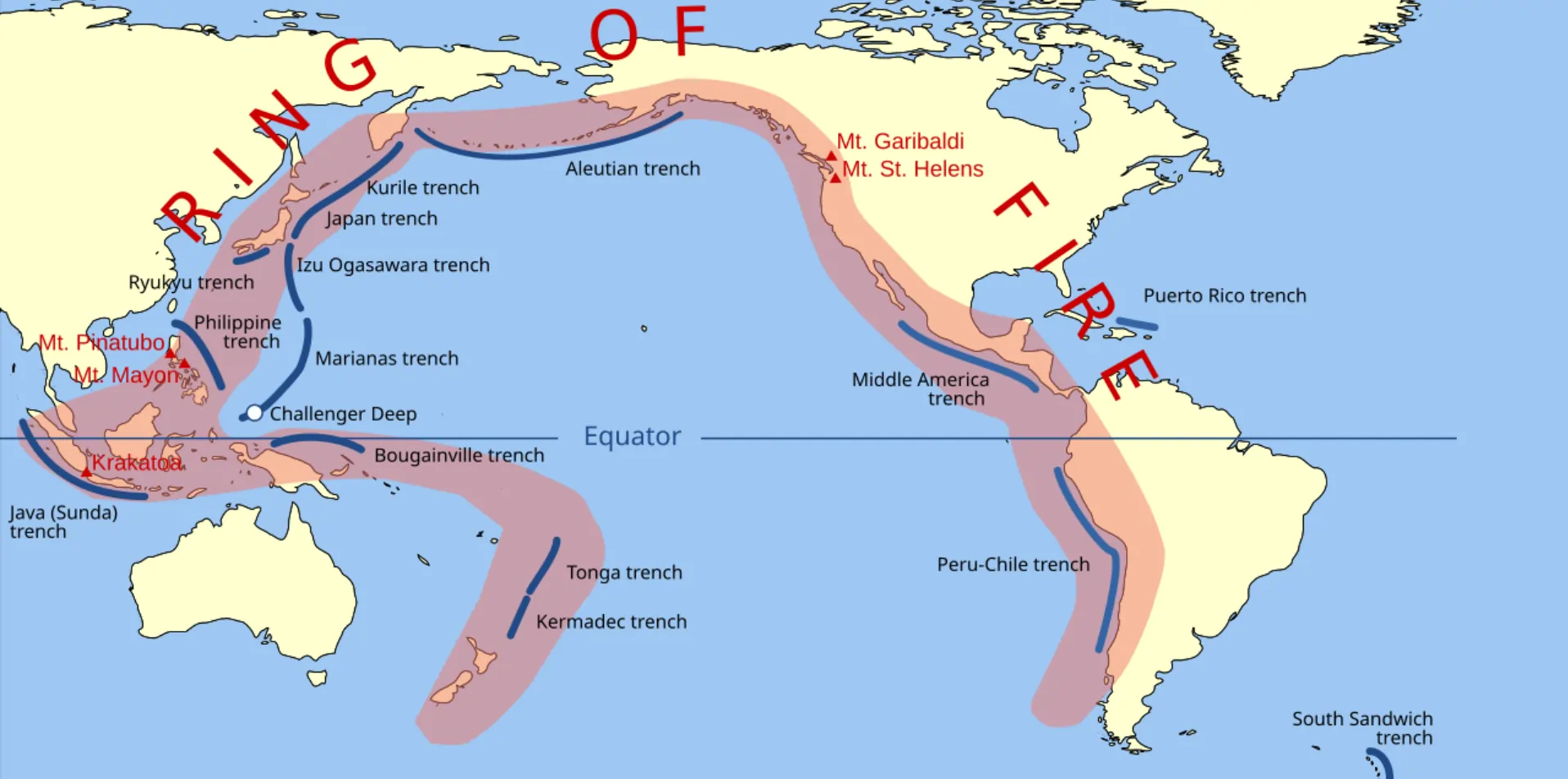
A horseshoe-shaped volcanic and seismic zone known officially as the Pacific Ring of Fire surrounds the Pacific Ocean and exists as the Ring of Fire to describe its intense tectonic activity. The geologically dynamic zone extends through the 40,000-kilometer border that connects American western coasts and Asian eastern coasts and Australian coasts. The region embraces over 75% of all active volcanoes and dormant volcanoes existing in the world which secures its standing as one of Earth's most volcanically and seismically active areas.
The Ring of Fire generates activity because of the way tectonic plates shift underneath Earth's crust. The Pacific Plate exists as the biggest tectonic plate which touches several neighbouring plates which include North American and Eurasian and Philippine Sea and Indo-Australian plates. Subduction together with divergent boundaries and hotspots serve as the essential mechanisms that activate volcanic activity throughout this geographical area. Subduction takes place when a tectonic plate pushes beneath an adjacent plate creating mantle sinking that produces magma by melting. The rising magma leads to the development of volcanoes at the surface of Earth. The Andes mountain range forms due to the Nazca Plate Subducting beneath the South American Plate along the western coast of South America while producing active volcanoes including Mount Villarrica and Mount Cotopaxi.
Volcanic activity reaches higher prevalence due to the distribution of mid-ocean ridges together with rift zones that primarily exist in the Pacific Ocean. Tectonic plates which separate from each other through divergent boundaries enable magma to appear at the surface. Some volcanic hotspots located inside the Ring of Fire emerge from rising magma plumes which originate at great depths beneath the Earth's mantle.
The Ring of Fire displays such intense geological volatility that affects every resident among its millions of surrounding population. The region's geological activities create localized dangers for people and infrastructure but simultaneously create new landforms and fortified soil conditions that promote local nature diversity and farming capabilities. Three major volcanoes on the Ring of Fire include Mount St. Helens in the United States and Mount Fuji in Japan alongside Krakatoa in Indonesia.
The Pacific Ring of Fire demonstrates Earth's constant active state in its entirety. Tectonic plate activity at this site creates volcanic and seismic phenomena that scientists and naturalists study while making it a notable scientific focus.
Conclusion
The Mount Lewotobi Laki Laki volcanic eruption illustrates the universal forces that mould our planet and the necessary ability for human survival among these forces. Future volcanic impacts may decrease because scientific monitoring of volcanic behaviour continues to improve while authorities enhance their disaster readiness protocols. The combination of technology investment and community education and sustainable recovery initiatives enables affected areas to build up in both strength and readiness. Our collective response to this event demonstrates how crucial it is to work together globally for life protection while understanding natural destructive forces.