UPSC Current Affairs
KOSI FLOODS & THE EMBANKMENT PARADOX
Context The Kosi River breached its embankment again in 2024, repeating past disasters such as the 2008 Kusaha breach that affected 33 lakh people. This raises fresh questions about whether concrete embankments actually protect flood-prone plains, or whether they worsen long-term vulnerability. Experts, local communities, and geologists are increasingly arguing for alternatives to embankment-based flood control.
VRAuthor Desk
4 min read
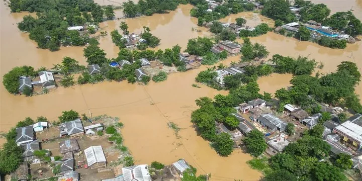
Context The Kosi River breached its embankment again in 2024, repeating past disasters such as the 2008 Kusaha breach that affected 33 lakh people. This raises fresh questions about whether concrete embankments actually protect flood-prone plains, or whether they worsen long-term vulnerability. Experts, local communities, and geologists are increasingly arguing for alternatives to embankment-based flood control.
Context
- The Kosi River breached its embankment again in 2024, repeating past disasters such as the 2008 Kusaha breach that affected 33 lakh people.
- This raises fresh questions about whether concrete embankments actually protect flood-prone plains, or whether they worsen long-term vulnerability.
- Experts, local communities, and geologists are increasingly arguing for alternatives to embankment-based flood control.
What are Embankments?
- Artificial walls made of earth, stone, or concrete built along rivers to “contain” water.
- Intended to prevent flooding, protect agriculture, and enable settlements.
ABOUT RIVER KOSI
• Origin & Course
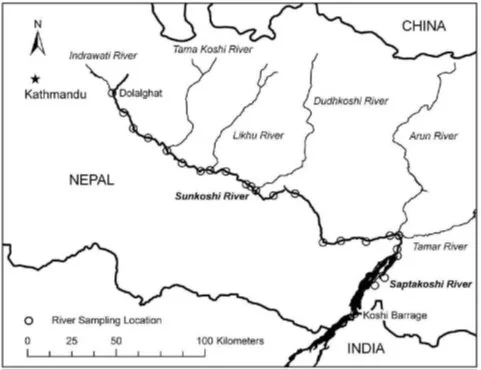
- Originates in Tibet (China), flows through Nepal, and enters India in Bihar.
- Known as Sapta Kosi (formed by 7 Himalayan tributaries - Sun Kosi, Arun, Tamur, dudh kosi, Indravati, Likhu, and Tamur).
- Joins the Ganga near Kursela, Bihar.
• Geographical Characteristics
- A high-sediment, braided Himalayan river.
- One of the most dynamic rivers in the world.
- Has shifted ~120 km westwards in the last 250 years due to natural sedimentation.
- Known as the “River of Sorrow” because of recurrent destructive floods.
 • Hydrology & Sedimentation
- Carries one of the highest sediment loads among Himalayan rivers.
- Natural tendency to avulse (sudden course shift).
• Flood Issues
- Major breaches of embankment: 1963, 1968, 1971, 1980, 1984, 1987, 1991, 2008, 2024.
- 2008 Kusaha breach:
- Affected 33 lakh people, over 400 deaths.
- Considered one of India’s worst flood disasters.
• Socio-economic Importance
- Supports agriculture in north Bihar’s plains.
- Floods bring temporary soil fertility but long-term devastation.
- Millions live in diara lands (between river and embankments).
- High migration from Kosi belt due to chronic flood risk.
• Western vs Eastern Himalayan Rivers
- Kosi is an affluent river (precipitation increases downstream).
- Eastern Himalayan rivers = high rainfall + weak geology ? embankments less stable.
- Western Himalayan rivers = more stable, embankments sometimes workable.
• Climate Change Angle
- Intensified monsoon bursts ? higher sediment load ? more unpredictable floods.
- Increased glacial melt may alter flow patterns.
WHY DO EMBANKMENTS FAIL?
• Historic Warnings
• 1951 G.R. Garg Committee warned embankments disrupt natural river functions:
• Land creation (erosion & deposition)
• Basin drainage
• People’s Commission reports highlight ecological distortions caused by embanking Kosi.
• Experts argue for
“living with floods” strategy instead of hard engineering.
• Science of the Problem
• High Silt Load
• Himalayan rivers carry enormous sediment.
• Embankments trap the river between two fixed walls that leads to silt accumulation, because of which
riverbed rises each year.
• Height Race
• To prevent overtopping, governments keep raising embankments ? unsustainable costs.
• When Breach Happens
• Breach is the sudden release of water from an elevated channel, leading to
catastrophic floods that are much worse than natural floods.
• Waterlogging & Flooding Inside Embanked Zone
• Communities living between embankments and river (the “diara lands”) get trapped and waterlogged.
Evidence of Repeated Failures
• Kosi breached embankments multiple times:
1963, 1968, 1971, 1980, 1984, 1987, 1991, 2008, 2024
• Similar patterns are seen in Brahmaputra (Assam), Gandak, Bagmati.
INFLUENT V/S EFFLUENT RIVERS
- Western Himalayan rivers ? influent (precipitation decreases downstream): Embankments may work better.
- Eastern Himalayan rivers (Kosi, Brahmaputra, etc.) ? effluent (precipitation increases downstream): Embankments are geologically risky.
Paleochannels
- Ancient abandoned river channels that naturally hold excess water.
- Reviving them improves natural drainage.
WHY FLOODS WITHOUT EMBANKMENTS ARE MILDER?
- Without embankments, rivers spread gently over floodplains.
- Silt distributes naturally ? fertility improves.
- Water levels drop faster.
- Damage is widespread but not violent.
US Example
- US Army Corps of Engineers removed embankments in several basins.
- Result: reduced catastrophic floods and restored wetlands.
THE POLITICS OF EMBANKMENTS
- In Bihar elections, political promises emphasise “flood-to-fortune” river-linking (Kosi-Mechi project).
- However, 5,247 cusecs diverted is negligible compared to Kosi’s 6 lakh cusecs during flood, proving river-linking will not reduce flood intensity.
IMPLICATIONS
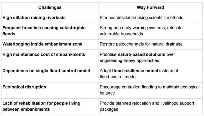
- Greater Flood Vulnerability due to siltation and breaches.
- Permanent Waterlogging for communities trapped between embankments.
- Ecological Degradation - groundwater imbalance, loss of wetlands.
- High Fiscal Cost - raising and repairing embankments every few years.
- Social Injustice - most affected are poor farmers, with little rehabilitation.
- Policy Blind Spots - engineering solutions overshadow traditional ecological knowledge.
- Prelims: Key facts, institutions, locations and terminology in the article.
- Mains: Connect the topic with Environment, Economy, Polity & Governance.
- Revision: Use the article headings to prepare concise notes and answer-writing points.
Test your understanding
Questions from this article
Prelims practiceWith reference to KOSI FLOODS & THE EMBANKMENT PARADOX, consider the following statements:
- The Kosi River breached its embankment again in 2024, repeating past disasters such as the 2008 Kusaha breach that affected 33 lakh people.
- This raises fresh questions about whether concrete embankments actually protect flood-prone plains, or whether they worsen long-term vulnerability.
- Experts, local communities, and geologists are increasingly arguing for alternatives to embankment-based flood control.
Which of the statements given above are correct?
- 1 and 2 only
- 2 and 3 only
- 1 and 3 only
- 1, 2 and 3
View answer
Answer: (d) 1, 2 and 3. All three statements are drawn from the article.
Mains practiceDiscuss the background, key issues and significance of KOSI FLOODS & THE EMBANKMENT PARADOX for India.
Answer in 250 words.
View answer approach
- What are Embankments?
- ABOUT RIVER KOSI
- WHY DO EMBANKMENTS FAIL?
- INFLUENT V/S EFFLUENT RIVERS
- WHY FLOODS WITHOUT EMBANKMENTS ARE MILDER?
Frequently asked questionsFrequently asked questions
Why is Kosi Floods & The Embankment Paradox in the news?
Context The Kosi River breached its embankment again in 2024, repeating past disasters such as the 2008 Kusaha breach that affected 33 lakh people. This raises fresh questions about whether concrete embankments actually protect flood-prone plains, or whether they worsen long-term vulnerability.
What are the key facts about Kosi Floods & The Embankment Paradox?
Experts, local communities, and geologists are increasingly arguing for alternatives to embankment-based flood control. Artificial walls made of earth, stone, or concrete built along rivers to “contain” water. Intended to prevent flooding, protect agriculture, and enable settlements.
Why is Kosi Floods & The Embankment Paradox important for UPSC preparation?
The topic connects current developments with Environment, Economy, Polity & Governance and is relevant for both objective revision and analytical answer writing.