A Tsunami Early Warning System refers to a system used in identifying tsunamis in the initial stages and alerting the communities on the potential dangers associated with the natural disaster. It consists of two critical components:
- Sensor Network: This network consists in installing probes at certain locations in the ocean. These sensors are used to monitor pressure changes that are out of the ordinary which could be as a result of underwater earthquakes or volcanic activities. In case those pressure variations shows abnormal behaviour, the data is transmitted to the surface buoys.
- Communication Infrastructure: After the data has been collected by the bottom pressure gauges, it is relayed to Surface Buoys which in turn send the data to the tsunami warning centres. Specialists of the Centre study the data and immediately inform the appropriate government offices in the regions concerned. Such warnings enable the people in the affected areas to escape thus reducing the effects of tsunamis.
How it works
Sensor Network:
- It works through the help of a tangent network of deployed sensors near most prominent faults in the ocean. These sensors remain active all the time for the purpose of detecting these seismic activities.
- When an earthquake happens such sensors observe sudden changes in pressure within the water column. Such changes signify that a tsunami warning can be expected.
- This information reaches surface buoys located above the sensors.
Surface Buoys:
- They are critical in the process of early warning system and they are regarded as the surface buoys. They get information from the other sensors mounted underwater.
- Whenever there are such pressure fluctuations the buoys relay this data to the tsunami warning stations.
- The information collected on these buoys can be transmitted in real-time to the scientist as well as other authorities.
Tsunami Warning Centres:
- Tsunami warning centres are active centres that functions all the time; and it is manned by professionals. For example in the United States, two such centres are crucial:
- Pacific Tsunami Warning Centre (PTWC): It is sited in Hawaii and it disseminates tsunami warnings for Hawaiian Islands, U.S. Pacific and Caribbean possessions and the British Virgin Islands. It also partners with others across the world.
- National Tsunami Warning Centre (NTWC): Located in Alaska, this centre offers emergency tsunamis messages for the countries of the United States of America, Alaska, and Canada.
The scientists at these centres study Seismic data, Magnitude, Epicentre, and Focal depth of the earthquake. They employ this information in deciding whether an earthquake has potential to produce a tsunami.Due to the fact that tsunamis can impact the neighbouring coasts in a few minutes, the preliminary seismological information serves as the first key to making decisions.
Issuing Tsunami Messages:
- In the course of a large shallow focus earthquake, scientists from the warning centres assess the capability it possesses for generating the tsunami.
- If they conclude that a tsunami is likely to occur then they release an initial tsunami alert.
- These messages give information to the commanders in the endangered coastal region so that they put into practice evacuation plans as soon as possible.
Observing and Measuring Tsunamis:
- Scientists also analyseactual tsunamis after existing occurrences.
- Information from water-level networks is used to observe the tsunami’s movement for a given time interval.
- Seismic data coupled with water-level data are used to refine the warning centres’ prediction and to release new alerts if necessary.
India’s Tsunami Early Warning System
The Tsunami Early Warning System in India, which is very important in terms of protecting coastal population against possible disastrous effects of the tsunami. The Indian Tsunami Early Warning System (ITEWS) a reliable software system which is being used as a network in order to detect tsunami-genic earthquakes and also used as a network for the monitoring of tsunamis and also used for timely issuance of advisories to the threatened coastal areas in the context of the Indian coastline. Here is the part and parcel of this system.
Seismic Stations:
- Land based seismometers stations were located in areas that are considered as seismically active zones that are associated with tsunami-genesis.
- Seismic stations record seismic waves in the event of an earthquake and also determine possible focal parameters include magnitude and location.
- The cases and conditions of the earthquake are transmitted concurrently to the Tsunami Warning Centre.
Bottom Pressure Recorders (BPR):
- BPRs are installed at different geographical coordinates in the sea. They can ‘sense,’ even slight altering of water pressure brought on by tsunamis.
- These recorders are capable of monitoring pressure fluctuations to the depths ranges up to 6 kilometres deep.
- From analysing BPR data scientists can actually detect probable tsunamis.
Tide Gauges and Tsunami Buoys:
- Gauges and Tsunami Buoys:
These instruments gauge measures changes in sea-levelling, which are key in pointing out the presence of tsunamis.
- Data from both the tide gauges and buoys are collected to improve the observations of the tsunamis.
Observational Network for Upper Ocean Parameters:
- It also keeps track during cyclogenesis of the upper ocean surface.
- It helps to enhance capability of predicting storm surges that are connected with tsunamis.
High-Resolution Databases and Vulnerability Modelling:
- For each of the cross- national comparative analysis, the system retains information pertaining to bathymetry, the coastal land use, and other parameters.
- Risk assessment of different regions using coastal vulnerability modelling and preparation of inundation maps are useful in determining the effect of tsunamis on given areas.
Tsunami Early Warning Centre (TEWC):
- The essence of ITEWS is the TEWC, which operates round the clock.
- With the computational and communication facilities, the TEWC is able to obtain data from seismic stations, BPRs tide gauges and other instruments in real time basis.
- This data is processed by custom built software that produces alarms or alerts when the pre-set thresholds are breached.
Capacity Building and Education:
- ITEWS targets to disseminate information about how stakeholders can use appropriately the maps, warnings and advisories.
- Training programs increase the levels of preparedness coupled with response measures.
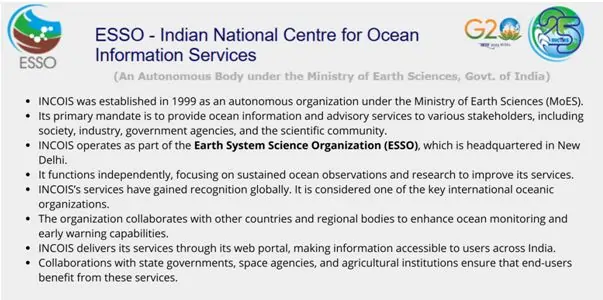
This works as an alarm for the Indian Ocean. It is administered by INCOIS (Indian National Centre for Ocean Information Services), Hyderabad. It uses advanced technological system, constant surveillance and the help of specialists in preventing enormous losses to coastal regions from tsunamis.
Tsunami
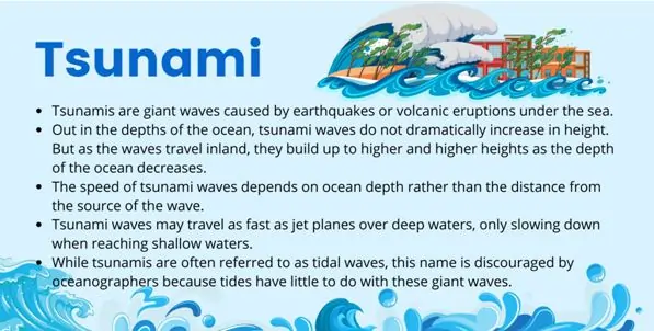
A tsunami is the seismic sea wave which is commonly referred to as the devastating wave that hits the coast with a lot of energy.
It can is caused by:
- Submarine Earthquakes: In the case where the earthquake happens at the base of the ocean; it brings about a shift of the huge mass of water instantaneously. These force dislocations produce a sequence of waves that move outwards from the epicentre of the earthquake.
- Underwater or Coastal Landslides: Notably, seismic activities that lead to huge movements of landmasses, especially those that occur underwater or close to the shore cause displacement of water leading to the formation of tsunamis waves.
- Volcanic Eruptions: Hydrothermal eruptions which occur with volcanic islands or seafloor spouting are expected to cause tsunamis.
Tsunami waves are distinct:
- Height:
can go up to 30 meters high when they hit the coastline.
- Speed: When in deep waters, the wave like formation of the tsunamis affects its movement in that it moves at a speed similar to that of a jet plane. But as they near the shallow water regions of the shores they throttle down.
- Energy: Tsunami is an immense phenomenon as it transfers a lot of energy owing to its long spectrum and volume of water moved forward.
Propagation and Impact:
- The waves of tsunami originate from the epicentre of major in-water landslides or the earthquakes.
- Whenever they migrate they may do it across whole ocean basins.
- When a tsunami advances towards the shoreline its energy concentrates and the waves stand up tall. Such augmentations in height can bring negative impacts which are fatal to coastal states and districts.
Steps the Government of India is taking to work effectively against Tsunami
- Indian Tsunami Early Warning Centre (ITEWC):After the devastating Indian Ocean tsunami of December 26 2004, the government of India put in place Indian Tsunami Early Warning Centre (ITEWC). This centre works under the Indian National Centre for Ocean Information Services (INCOIS) that is located in Hyderabad and comes under the Ministry of Earth Sciences.
- Timely Warnings and Dissemination:ITEWC is capable of registering tsunami-genic earthquakes within as short a time as 10 minutes before they occur. Once the event gets detected, it issues alerts immediately to the concerned parties using email, fax, Short Messaging System, Global Telecommunication System and its website.ITEWC operated under the UNESCO-IOC framework involves moving collaboration with other countries which form the rim of the Indian Ocean in the area of tsunami preparedness and response.
- Community Awareness and Preparedness:considering the fact that there is need for community preparedness, ITEWC participates in awareness programs. Workshops, trainings, and seminars are held to inform the stakeholders about the occurrences and effects of tsunamis.
- Tsunami Ready Program:India is one of the members in the Tsunami Ready Program, which is from the Inter-governmental Oceanographic Commission (IOC) of UNESCO.It is precisely based on community performance Based Preparedness. In this the disaster management system strives to prevent loss of life and property, by meeting certain best practice indicators by the Intergovernmental Coordination Group for the Indian Ocean Tsunami Warning and Mitigation System (ICG/IOTWMS).These indicators guarantee that communities are well protected through functional end to end tsunami early warning and post mitigation system with strong focus on community awareness and readiness.
- Overall Disaster Risk Reduction Efforts:Efforts made by India for Tsunami are in accordance with the Sendai Framework for Disaster Risk Reduction (SFDRR) 2015-2030, focusing at ‘Risk reduction, prevention, preparedness, and building resilience’.In this regard, early warning systems, community preparedness initiatives of India will prove helpful in achieving the goal of creating safer and more resilient global societies.